
It doesn’t take a rocket scientist to notice that our cities are getting more crowded – particularly at the curb. Once used by payphone booths and newspaper kiosks, the curb has become the prime area for the congregation of “micro-mobility” options such as e-scooters, e-bikes, rideshare services, as well as old-school mainstays which include taxis, delivery vehicles, public transportation and, oh yeah … pedestrians.
All this demand has suddenly made the curb a valuable piece of real estate for cities. As such, cities are looking for new ways to regulate, manage, and monetize its usage.
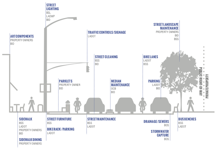
To say this is a challenge is an understatement, as the different properties of the curb are controlled by different departments and perhaps even different branches of the local government. In short, there are lots of “cooks in the kitchen” when it comes to producing curb regulations. The example below for the City of Los Angeles highlights how many different departments are involved:
Source: COORD
This has resulted in new opportunities for high-tech start-ups looking to help cities meet the challenge to reduce the chaos at the curb through the use of maps data, sensors, apps and on-demand management.
In fact, the curb has become so important, that The International Transport Forum (an intergovernmental organization with 59 member countries that covers all transport modes at the OECD) has issued an extensive report on how to manage growing competition for curb access in cities.
One of its recommendations and a good starting point is the need to digitize information about streets and curbs to include everything from parking signs, loading zones, fire hydrants, special access restrictions, and more. This allows a city to not only know the exact location of every curb, but provides the ability for cities to evaluate its current space allocation against curbside users’ demands, enabling more effective curb space allocation as well as the ability to implement dynamic management schemes.
The second step is to make this information accessible for public as well as private actors. This allows for rapid and automatic integration of curb and street use rules directly into third-party apps and algorithms to enable dynamic and flexible allocation models
The goals of these recommendations are to reduce congestion and improve land use at the street level as well as provide cities with the tools for more informed policy changes, regulation, and compliance along the curb. This way as more (roller skates anyone?) mobility options come into play, there will be better integration into existing transit systems, while identifying new avenues for revenue as transportation methods evolve – such as variable pricing, scooter or bike parking, or even minute-by-minute parking for ride-hail or loading zones.
A few key startups helping cities with their curb appeal are highlighted below:
- COORD, a spin-off of Alphabet’s (Google’s parent company) Sidewalk Labs, has developed a number of solutions to address the curb. The Surveyor app, used to map and analyze curb features, combines data from existing platforms such as Google Street View with advances in computer vision and machine learning to accurately position curb assets on digital maps. On average, the Surveyor app can digitize a city block face in under three minutes. In addition, COORD has launched Open Curbs, an open, multi-city platform that makes standardized curb data publicly available through an open database license to city agencies, engineering firms, mobility providers and community groups, to enable better understanding of city accessibility. This enables curb users such as mobility and logistics providers be more efficient and compliant, while allowing for better routing and improved congestion.
- curbFlow is primarily focused on efficiently orchestrating commercial operator pickup and drop-off activity to available curb space in real time. Working with Washington DC's District Department of Transportation (DDOT) on a three-month pilot program has shown a 64% reduction in double-parking when commercial vehicles had to reserve space. The pilot is providing the DDOT with a better understanding of the overall volume of activity at the curb and what types of activities are occurring.
- Passport, in addition to its mobile pay parking management app, has pilots in Charlotte, Detroit and Omaha to analyze scooter usage patterns and determine how to charge for curb space.
Collaboration is key
I’ve said this before and it still rings true. With smart city applications, collaboration across all key stakeholders – citizens, NGOs, public, and private sectors – is critical to their success. Even though technology is an enabler, it can’t do it all on its own.
Cities certainly don’t want to curb the enthusiasm for its curb, but they do want to find ways to rethink how they use their curbs and envision them as dynamic, highly flexible and self-adjusting spaces that make urban areas equitable and livable.